- Start your journey in historic and art-filled Marfa, Texas, where you can see large-scale artworks at Donald Judd’s Chinati Foundation, and enjoy a hearty Tex-Mex lunch at Marfa Burrito.
- Take in the Chinati Mountains as you drive along Pinto Canyon Road, which winds between Marfa and Presidio, Texas.
- End your drive with a stay at Chinati Hot Springs, and soak in the steaming springwater beneath rustling cottonwoods and the glittering expanse of Texas stars.
As you drive out of Marfa on Ranch Road 2810, miles of open land sprawl out on all sides, with green and golden swaying grass speckled here and there with cattle. The rolling hills seem endless—but drive far enough, and the landscape shifts.
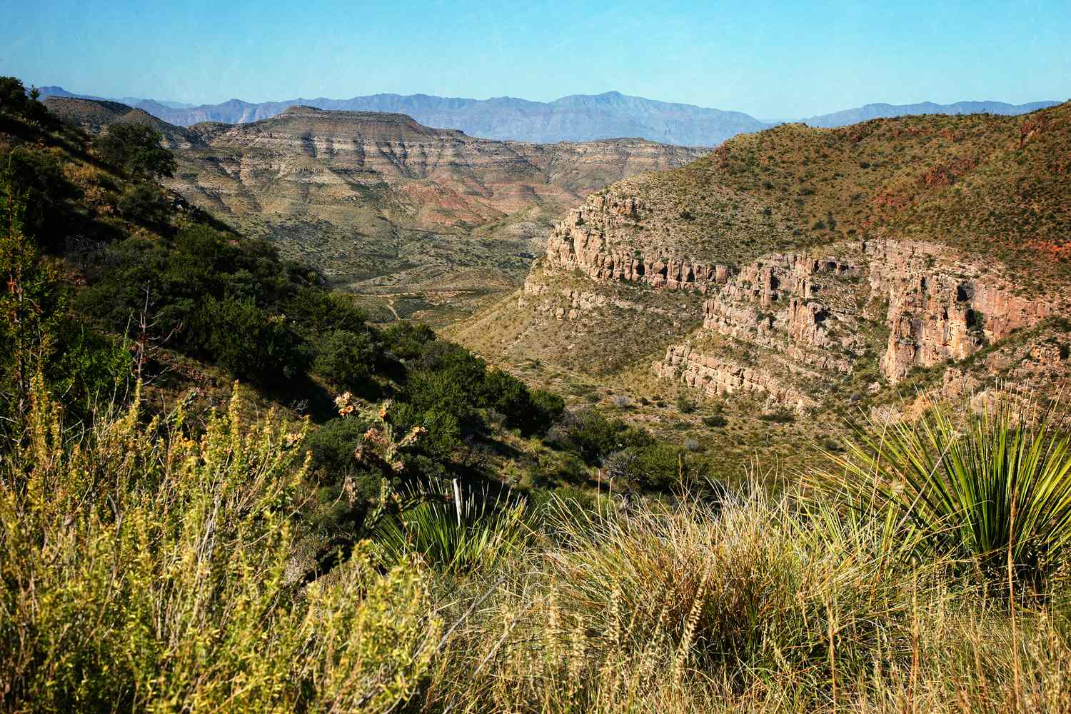
Suddenly, around 32 miles southwest of Marfa, the pavement ends, the ground drops away precipitously, and the gentle plains give way to craggy rocks and steep, dramatic mountains. If you keep driving, you’ll descend into Pinto Canyon along the Pinto Canyon Road, one of the most stunning drives in the state of Texas.
“You’re winding around those hills up above the canyon, which was a part of an ancient caldera … and then you drop down into it and the land opens up,” says David Keller, author of “In the Shadow of the Chinatis,” a book that chronicles the history of the canyon. “You can see from there all the way into Mexico. It’s a giant chasm, and you descend into it. It’s kind of otherworldly.”
The landscape of Pinto Canyon was born in an eruption of fire and magma, created by an ancient volcano that was several times larger and more powerful than Mount Saint Helens. The volcano set the stage for the landscape of rough volcanic peaks, which have since been shaped by millennia of erosion and tectonic activity.
As it winds past geological wonders, Pinto Canyon Road also passes through evidence of the canyon’s human history. Once a stronghold for Native American communities (especially the Apache) the land was later settled by ranchers who staked a claim under 1905’s Eight Section Act, which doubled the amount of land one could homestead.
Generational successes and made-for-TV tragedies played out across the canyon’s rugged scenery as families struggled to make a living in their harsh surroundings. As Keller writes in his book, “a landscape is never simply a passive backdrop for the play of history, but here aridity and toppled topography [conspired] to force it center stage.”
In the coming years, there will be more public access to the Chinati range: the state of Texas owns a property nearby, and is currently working on turning it into a new park, Chinati Mountains State Natural Area.
For now, Pinto Canyon Road is the best way to see this magnificent country. To drive the road, you should have a car with high clearance and all-wheel drive. The road’s hairpin turns and gravelly washes mean slow going; the trip from Marfa to Chinati Hot Springs will likely take around two hours. Download the map on your phone before dropping into the canyon to ensure you’ll be able to navigate, and as with any desert road trip, stock your car with extra water.
Do not attempt to drive Pinto Canyon Road after rain or in inclement weather. If you’re driving during the rainy season between July and September, be alert for flash flood conditions. If you encounter a creek that is flooding, don’t attempt to cross. Just wait it out and cross when the water recedes.
Here’s what you need to know before planning a trip on Pinto Canyon Road.
Begin your drive in Marfa.
Peter Blottman Photography/Getty Images
Over the years, the small town of Marfa has become a favorite among artists seeking the solitude of the desert. Spend the night before your drive here at the historic Hotel Paisano or the posh Hotel Saint George. In the morning, enjoy a few leisurely hours exploring town. See large-scale artworks at Donald Judd’s Chinati Foundation, and check out Moonlight Gemstones to see (and maybe purchase) the feathery, milky wonder of West Texas agate. In the mid-to-late afternoon, when the light feels right for a scenic drive, set out on your journey south.
Head down into the canyon.
Mabry Campbell/Getty Images
You can access Pinto Canyon Road—a 60-ish mile stretch of Ranch Road 2810—by driving south out of Marfa on South Hoover Street. This will take you 32 miles through the Marfa Plain before the pavement ends and drops you into Pinto Canyon. Shortly after entering the canyon, a pull-out will allow you to stop and take in the expansive views of volcanic landforms, crisscrossed by livestock trails, before descending further.
View the relics of ranching history.
As you drive the road, you’ll pass old fences and the ruins of adobe houses. Several families settled in the canyon—one, the family of goat-herd-turned-successful rancher Jose Prieto, stayed the longest. Prieto, a Mexican immigrant, started out living in a tiny mountain dugout and eventually assembled a 12,000-acre ranch. He persevered through devastating droughts, the financial insecurity of the Great Depression, and a series of family tragedies that would devastate his household and ultimately lead to their departure from the canyon.
“Jose Prieto’s house is visible from the road,” says Keller. “There’s a lot of physical evidence of history there that reveals the fact that Pinto Canyon was a small community at one time. It was much more populated than it is today.”
Stop for photos of the Chinati Mountains.
Mabry Campbell/Getty Images
As you proceed further into the canyon, Chinati Peak will be visible on your left. At 7,728 feet, the mountain is the highest point in Presidio County. The Chinati Mountain range likely gets its name from the Apache word ch’íná’itíh, which means “gate” or “mountain pass.”
Soak it up at Chinati Hot Springs.
Toward the end of Pinto Canyon Road, the path forks. The route on the right will take you to a beautiful desert hot springs resort, Chinati Hot Springs. Here, water from deep beneath the earth emerges at around 113 degrees Fahrenheit. A tiled pool provides a restful place to soak in the steaming waters beneath a grove of rustling cottonwoods. A cold pool with a view is a short walk uphill through the resort. Reserve a cabin ahead of time, as Chinati Hot Springs does not have day passes and books up quickly.
See the Ruidosa Church.
Pinto Canyon Road comes to an end when it hits FM 170 at Ruidosa. In this tiny riverside town, you can see another piece of the history of the area, El Corazón Sagrado de la Iglesia de Jesús, or the Sacred Heart of the church of Jesus. The church was built in 1915, but in the 1950s, as the population of Ruidosa declined, the building fell into disrepair. Now, a group called Friends of the Ruidosa Church is working alongside preservation specialists to restore the historic structure.
Drive the River Road.
John/Adobe Stock
If you still have a hankering for scenery once you finish driving Pinto Canyon Road, head southeast past Presidio to drive another of the state’s scenic drives, a part of FM 170 known as the River Road. Tracing the contours of the Rio Grande through Big Bend Ranch State Park, the River Road passes hoodoos and a dizzying overlook called the Big Hill. Accessible from the road are several hikes in the state park (pay your park fee at the Fort Leaton State Historic Site), including Closed Canyon, a slot canyon with high, smooth walls. Visit in spring for a chance to see the road lined with tall and lanky Big Bend bluebonnets.
Read the full article here